
Winkelwagen
U heeft geen artikelen in uw winkelwagen

TZ Navigator Wide package includes the marine software navigation TZ Navigator and a chart area to be selected from a wide variety of electronic marine charts.
In the US, TZ Navigator includes free NOAA US raster and vector high resolution charts covering the entire US Coast, including Alaska, Hawaii, Pacific Islands and Great Lakes.Â
Designed for sailboats and motorboats cruising in the USA, TZ Navigator fully meets all needs for safe navigation through all TIMEZERO main features:
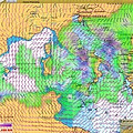
Marine weather forecast service
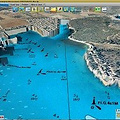
TIMEZERO now includes extremely realistic. Marine cartography, 3D data and satelite images are combined to give you the best information. Simultaneously visualize where you are and your entire journey with the utmost precision to better anticipate your way.
0 sterren op basis van 0 beoordelingen
Je beoordeling toevoegen


